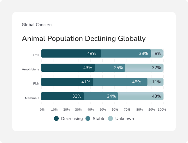
Revolutionizing wildlife protection
with AI-driven drone technology

From dense forests to deep waters, Aerowildtech’s intelligent drones deliver unmatched
surveillance to help save endangered species — fast, accurate, and eco-friendly.

The silent extinction crisis is accelerating

Wildlife is disappearing at an alarming rate — and we’re running out of time.

Mass extinction

70,000+ Species face extinction, with 48% already in decline.

Canadian crisis

In Canada alone, over 800 species are endangered, despite vast untouched land.

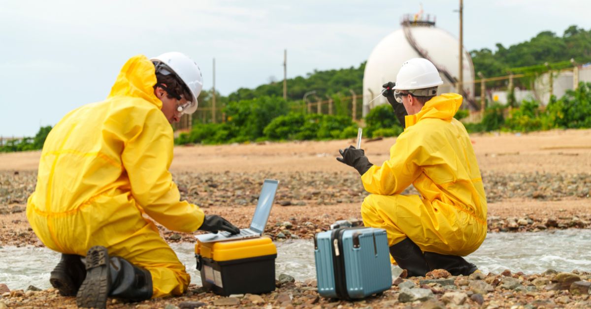
Inefficient surveillance

Traditional patrols are too slow, too expensive, and ineffective across large terrains.

Wildlife crime

Wildlife crimes like poaching and illegal trade are fueling a $20 billion black market.
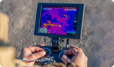
Aerowildtech Drones: The Future
of Wildlife Protection

Our multi-environment drone system uses cutting-edge tech to scan, track, and report
animal movement, habitat changes, and ecological risks — all in real time.

Thermal imaging

Thermal Imaging to detect animals through dense forests or night conditions.

Night vision

Night Vision for 24/7 surveillance

Underwater navigation

Underwater Navigation to explore aquatic ecosystems

Machine learning

Adaptive machine learning for smarter tracking over time

Ultra-low noise

Ultra-low noise and environmental impact
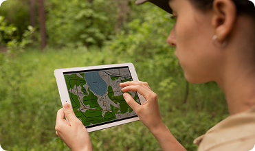
Real-time data

Real-time AI-powered data streaming and alerts

Why wildlife experts choose Aerowildtech

Our drones don’t just fly — they make a measurable difference on the ground. With Aerowildtech, conservation efforts become smarter, faster, and more effective.

Compared to traditional methods, our drones provide 43–96% higher tracking accuracy in tracking wildlife.

Compared to traditional methods, our drones provide 43–96% higher tracking accuracy in tracking wildlife.

Compared to traditional methods, our drones provide 43–96% higher tracking accuracy in tracking wildlife.

Compared to traditional methods, our drones provide 43–96% higher tracking accuracy in tracking wildlife.

Compared to traditional methods, our drones provide 43–96% higher tracking accuracy in tracking wildlife.

Compared to traditional methods, our drones provide 43–96% higher tracking accuracy in tracking wildlife.

From deployment to impact how
Aerowildtech works
Aerowildtech’s advanced drone system is engineered for precision and reliability
across diverse applications.
01
Deploy and launch

Our drones are launched manually or via pre-set flight programs — tailored for the terrain and target species.

Detect and monitor
02

Using multispectral sensors, night vision, and thermal cameras, the drone collects high-res visuals and environmental data.

03
Report and act

Automated alerts, reports, and visualizations are shared with conservation teams — enabling rapid response and proactive protection.

Our impact, told by the
people who use it
Hear from users how Aerowildtech’s precision, reliability, and ease of
use transform operations in extreme terrains and challenging conditions.
Sarah M.
Sarah M.Land Surveyor
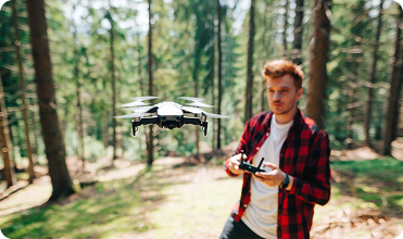
Aerowildtech’s drones have been a game-changer for our surveying team. The pre-programmed flight paths make deployment a breeze, and the tracking accuracy is unmatched, even in the rugged mountains we work in.
James T.
James T.Environmental Researcher
We operate in extreme weather, and Aerowildtech never fails us. From heavy rain to high winds, the drones deliver precise data every time, saving us hours of work.
Maria L.
Maria L.Wildlife Conservationist
The ease of use is incredible. We set up complex flight paths in minutes, and the drones handle tough terrain like it’s nothing. Aerowildtech has transformed our operations.
Latest insights
Hear from users how Aerowildtech’s precision, reliability, and ease of use
transform operations in extreme terrains and challenging conditions.

Canada’s 2023 wildfire season burned 16.5 million hectares of land. This was more than double the previous record and nearly seven times the historical average.

Have questions? We’ve got answers

Get answers to your questions about Aerowildtech’s AI drones, covering their superior tracking accuracy, performance in extreme conditions, and easy deployment with pre-programmed flight paths.

What is Aerowild Tech?

Aerowild Tech is a Canadian environmental monitoring company building multi-environment drone systems and an AI-driven data platform designed to help governments, researchers, Indigenous guardians, and conservation groups monitor wildlife and remote ecosystems more safely, accurately, and affordably.
Our mission is to improve visibility in Canada’s remote landscapes and reduce the risks and costs of traditional monitoring.

Canada loses critical wildlife and environmental data simply because much of the country is too remote, too expensive, or too dangerous to monitor regularly.
Traditional methods, helicopters, on-foot surveys, irregular satellite imagery, are:

  • extremely costly

  • high risk for field staff

  • limited in coverage

  • slow to detect changes

Aerowild Tech closes this monitoring gap by delivering continuous, affordable, low-risk environmental insights using drones and automated analytics.

According to the business plan, our primary target segments are:

  • Federal and provincial environmental agencies

  • Wildlife conservation departments

  • Indigenous Guardian and land stewardship programs

  • Forestry and natural resource authorities

  • Universities and ecological researchers

  • NGOs and conservation organizations

These groups face the strongest need for safer, more cost-efficient, large-area monitoring.

Quiet operation and non-invasive monitoring are core requirements in the Aerowild Tech design.
Our system incorporates:

  • low-noise propulsion

  • high-altitude observation

  • gentle approach patterns

  • the ability to detect wildlife without flying directly overhead

The business plan emphasizes minimal wildlife disturbance as a competitive advantage.

Based on the sensor modules defined in the plan, our drone system can capture:

  • Wildlife counts and movement patterns

  • Thermal signatures

  • Habitat changes (vegetation, canopy gaps)

  • Waterway and wetland conditions

  • Early indicators of environmental threats (fire, drought, flooding)

All data feeds into our analytics dashboard, giving clients actionable insights rather than raw files.

The business plan references global studies showing drones can deliver 43% to 96% higher accuracy in wildlife counts than manual methods.
By combining drones with AI detection, Aerowild Tech strengthens accuracy through:

  • automated species identification

  • heat-based detection

  • repeated aerial surveys that build trend data

This accuracy is one of our strongest value propositions.

Aerowild Tech enhances, not replaces, field teams. Drones and AI provide the early warnings and broad coverage. Humans provide the expertise and on-the-ground action.

Together, they form a modern monitoring ecosystem.